Services
d.1| GIS (Geographic Information System)
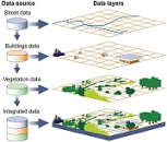
GIS (Geographic Information System) — is a computer system used for collecting, storing, checking, integrating, manipulating, analyzing and visualizing geographic data and geospatial. GIS consists of: Digital data — Geospatial information that you will show you and will be analyzed using computers and programs; Computers — computers and/or servers used to store, display and processing data; Software — running on comp...
Find out mored.2| THEMATIC MAPS

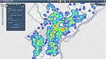
Spatial analysis includes techniques which studies the relationships between entities, in terms of topological geometry or geography. The emergence of a potential disaster depends on two factors: hazard and vulnerability. Hazard is the likelihood of a potential devastating phenomenon and that vulnerability is the degree of destruction resulting from the occurrence of the phenomenon. Risk analysis should be part of any project or risk man...
Find out mored.3| DIGITAL CARTHOGRAPHY
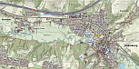
Cartography, is in charge of drafting, editing and drawing maps. Paper maps provide basic information of reality, but they lack specific details that help us better understand landscape. Updating information on printed map is very cumbersome, and printing a new edition/version happens more often at distances of time, so that in very few cases we have accurate information in real time. Digital Cartography, is the process by which a da...
Find out mored.4| WebGIS
Web Mapping is the process of generation and distribution maps using the WWW and its characteristics. While Web Mapping addresses to the technological problems, Web Cartography its studying theoretical aspects: the use of web maps as services, evaluation and optimization techniques and workflows, utility maps, social issues and more. WebGIS is similar with Web Mapping, further emphasis on the analysis and processing of geographic data. (sourc...
Find out mored.5| SPATIAL DATABASE
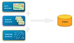
Spatial database is a database that has the additional textual ability to store and query data representing objects defined in a geometric space. Most databases allow representing objects by points, lines, polygons or more complex structures: 3D objects, topology, linear networks, etc. The main RDBMS used in GIS are: Microsoft SQL Server - the way how POLYGONS geometry it's stored ((x1 y1, x2 y2, x3 y3, x4 y4, x5 y5)) eg. DECLA...
Find out more