
Services
e.1| DATA PROCESSING

Introduction, validation and processing; Interogation, sort, filter data; Data Conversion, analog - digital;
Find out moree.2| SERVICES SCANNING AND PLOTTING
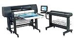
Scanning - formats/fabric (paper): A5 (148x210mm) - surface:0.03mp A4 (210x297mm) - surface:0.06mp A3 (297x420mm) - surface:0.12mp A2 (420x594mm) - surface:0.25mp A1 (594x841mm) - surface:0.5mp A0 (841x1189mm) - surface:1mp A0+(914x1219mm) - surface:1.1mp - film(roll diameter 168mm): 320x320mm or 320x450mm Plotting - formats/fabric (Photo paper, Adhesive foils, Paper PP, PVC Sticker, Film, Canvas, Rigid PVC Film, Banner...
Find out moree.3| VECTORIZATION

Conversion plans and/or maps of the classic support (printed paper) in various digital formats. It can be executed by digitizing characteristic elements, resulting in plans/maps into a vector format with multiple possibilities of exploitation.
Find out moree.4| TOURIST MAP
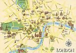
Tourist maps, and formats performed at various scales representing numerous points of interest and/or specific information with a focus on a specific interest. Tourist Map: Zebil City Tourist Map: Sibiu City Tourist Map: Timișoara City Tourist Map: Vama City Tourist Map: Breaza City Tourist Map: Giurgiu City
Find out moree.5| TEHNICAL FEATURES
No. Name Units Description 1. Land survey devices 1.1 Total station TOPCON GTS 211D 4 Precision: 5" 1.2 Total station TOPCON GTP 3007N 1 Precision: 7" 1.3 Total station TOPCON GTP 7501 1 Precision: 1" 1.4 Total station TOPCON GPT 3105N 1 Precision: 5" 1.5 Total station NIKON DTM 332 2 Precision: 5" 1.8 GPS receiver THALES Navigation PROMARK 2 6 Precision: 0.005m+...
Find out more