
Services
a.1| DOCUMENTS

You can download these forms, they are in Adobe Acrobat Reader [.pdf] format, and you can print and fill them out. Annex 1.11 - Request consultation documents from the archive. This form must be completed when you want to obtain copies of the original records of the OCPI. (332 KB) Annex 1.22 - Application for registration. This form will be needed for the registration of: tabulation, provisional registration, grading or cancellation of...
Find out morea.2| LEGISLATION

Republished Law no. 7/1996 of the cadastre and real estate advertising, with amendments and supplemented. (223 KB) Law no. 255/2010 about expropriation for public utility necessary to achieve objectives of national, county and local level, republished, with amendments and supplemented. (295 KB) Land Law no. 18/1991, republished, with amendments and supplemented. (484 KB) Law no. 17/2014 regarding some measures to regulate the sale...
Find out morea.3| PARCEL PLANS
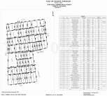
Parcel plan is a graphical representation of a land parcel that contains all the buildings from a lot limits and stable details that define. It is prepared in analog and digital format and integrate cadastral plan after its receipt by the territorial office by assigning cadastral numbers of all the buildings components and their registration in the Land Register Book. The legal aspect of this parcel from this document is confirmed by the names ...
Find out morea.4| REAL ESTATE AND URBAN CADASTRE

Real Estate Cadastre Cadastre estate fund accounting and inventory are property bodies of municipalities, specifying the use of construction, building materials, the structure of stores, foundation, surface, amenities and condition. The system manages territorial entities which have the property reference unit (defined by law cadastre as one or more parcels of land with or without buildings). The preparation is done by updating cadastral plan ex...
Find out morea.5| PROPERTY RECONSTITUTION
Required documents: Sale contract; Succesion certificate; Property title; Court rulings; Civil status documents (marriage certificates, death certificates, if applicable); Topographical plans as follows: Initial situation of the plot (if possible as described in the documents of ownership); The current situation of the plot. Activities developed by the company: study the content of the property following the history of t...
Find out morea.6| CADASTRAL DOCUMENTATION FOR ENROLLMENT IN THE LAND REGISTER

The integrated cadastre and land registry that contains technical, economic and legal buildings records, from the same administrative unit: commune, town or municipality. The following immovable property rights can be tabulated in the land registry: ownership and its dismemberments, real rights corresponding to public property rights, real warranty rights. Registration shall be made only on the basis of authentic document signed by a notary p...
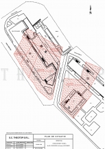
Find out morea.7| TOPOGRAPHIC MAPS AND PLANS
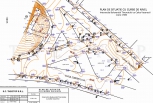
Topographic maps and plans are conventional graphics that issues of planimetry and relief of the earth's surface, a general or detailed, depending on the scale of clerical and other criteria.Topographic map is a graphical representation of conventional large land areas, which takes into account the shape of the curve of the Earth, based on the use of cartographic projections. In terms of content, a general topographic maps render details pl...
Find out morea.8| DOCUMENTATION FOR APPLYING HG. 834/1991

The purpose of this paper is to obtain certification of ownership of land in use state-owned companies, according to GD 834/1991. Required documents: Floor plan of the area; Title deeds; Decisions of the Government Decrees, Laws establishing a company or Administration; Certificate of trade registration; Any other document certifying the acquisition of ownership. Terrain documentation includes: Technical report; Old inventory c...
Find out morea.9| CONSULTING

We offer this service to any potential client, we give you an expert advice counseled for any technical or legal issue. Our staff is trained to answer all your questions. We expect you at the headquarters with the ownership documents to explain exactly what are the necessary documents depending on the type of your cadastral documentation. If you want to avoid unpleasant surprises when you purchase a house you just have to follow a few simple s...
Find out morea.10| TECHNICAL FEATURES

TOTAL STATION TOPCON GTS 211D Features: 2000 memory records; maximum distance measurement to within 3mm + 2ppm, is up to 550m with a small prism, normal prism up to 1100m and with a honeycomb 3 prism up to 1600m; Angle measurement accuracy is 5"; two-axis compensator; minimum measurement time is 0.3"; 26x zoom increase. TOTAL STATION TOPCON GTP 3105N Features: 2Mb(Flash ROM) + 128Mb(SD Card) alphanumeric keyboard; maximu...
Find out more- 1|
- 2|
- 3|
- 4
- next page »